When the Smoke Rises Over East Texas, a New Kind of First Responder Takes to the Sky
There is something deeply unsettling about watching a wildfire crest a ridge and knowing that ground crews alone may not be enough. We have seen it firsthand here in Elkhart TX, where dry summers and dense pine forests create a tinderbox that can ignite without warning. That reality is exactly why we built our aerial firefighting services around a technology most people still associate with photography and package delivery: drones. At Doss Drone Services, our mission is to put unmanned aerial systems into the hands of the people who need them most — rural fire departments, landowners, and emergency managers — so that wildfire suppression is faster, safer, and smarter than it has ever been before. This article walks through how drone firefighting services are changing the game, how our team operates in the field, and why communities across East Texas are beginning to rely on aerial fire suppression services as a critical layer of defense.
Why Elkhart TX and the Surrounding Region Need Aerial Firefighting Services Now More Than Ever
The Growing Wildfire Threat in East Texas
If you have driven the backroads around Elkhart TX in late summer, you have seen the brown, brittle undergrowth that lines every fence row and timber stand. East Texas wildfire response has become a year-round conversation, not just a seasonal concern. According to the Texas A&M Forest Service, the state has experienced a dramatic uptick in wildfire acreage burned over the past decade, and our region sits squarely in the crosshairs. Dense loblolly pine plantations, mixed hardwood bottomlands, and vast stretches of privately owned ranchland create an environment where a single spark can turn into thousands of scorched acres before traditional resources even arrive on scene.
Our area faces unique challenges that make conventional wildfire suppression difficult. Many properties are accessible only by single-lane county roads. Water sources can be miles apart. Volunteer fire departments — the backbone of rural emergency response services in Anderson and Houston counties — often operate with limited budgets and aging equipment. When a fire breaks out in a remote timber tract at two in the morning, the question is not whether we need help from the air, but how quickly that help can arrive.
Why Traditional Aerial Assets Are Not Always the Answer
Manned aircraft have served wildfire suppression efforts heroically for decades, but they come with significant constraints that communities like ours feel acutely:
– Cost: A single-engine air tanker can run upward of $8,000 per flight hour, and large air tankers cost even more. For a small rural fire department, requesting aerial support can consume an entire annual budget in a single afternoon.
– Availability: During peak fire season, manned aircraft are stretched thin across the entire southern United States. East Texas wildfire response often competes with fires in Oklahoma, Louisiana, and the Hill Country for the same limited fleet.
– Night restrictions: Most manned aerial firefighting platforms cannot safely operate after dark, leaving ground crews vulnerable during the critical overnight hours when shifting winds can push a fire in unexpected directions.
This is the gap that aerial firefighting drones are designed to fill. They do not replace helicopters and tankers. They supplement them, providing capabilities that manned platforms simply cannot match in terms of speed of deployment, cost efficiency, and operational flexibility — including night operations that would be impossible with a crewed aircraft.
How Our Drone Firefighting Services Work in the Field
Initial Attack, Extended Attack, and Everything in Between
When our team receives an activation call, the clock starts immediately. We have built our aerial firefighting services around the concept of rapid, scalable response. Here is what a typical deployment looks like:
1. Alert and mobilization — We coordinate directly with rural fire departments and emergency managers through the incident command system (ICS) framework, ensuring that our unmanned aerial systems integrate seamlessly with ground operations.
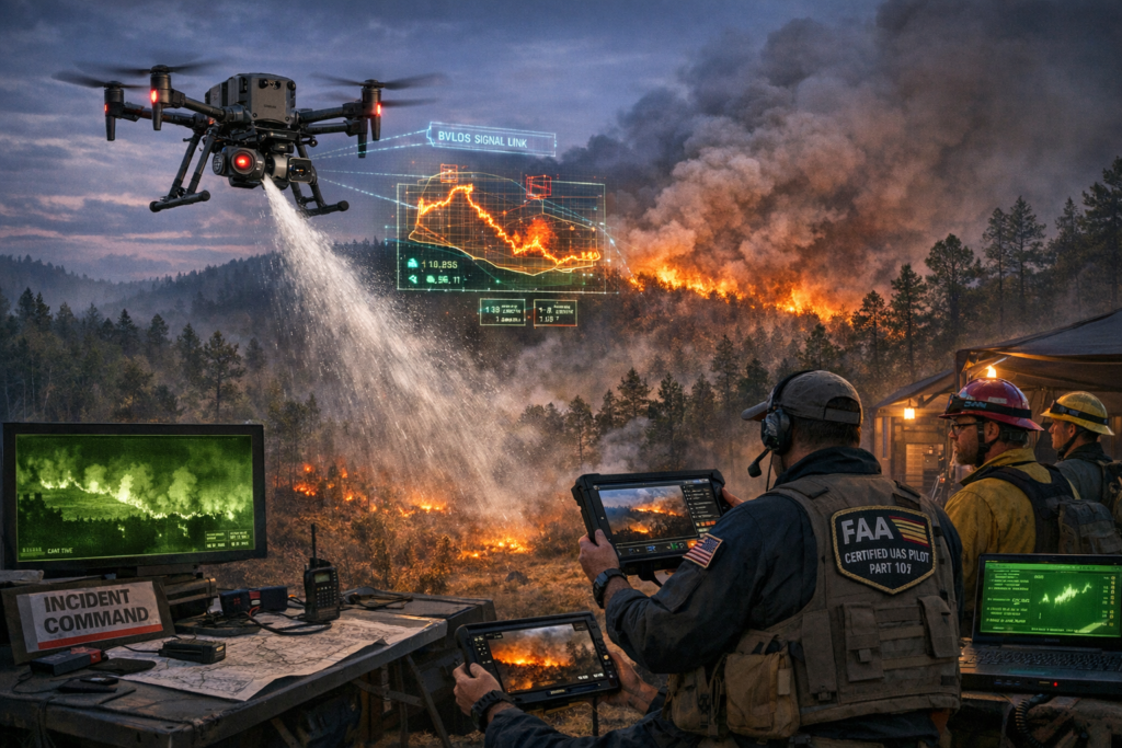
2. Launch and reconnaissance — Within minutes of arriving on scene, we put thermal imaging drones into the air to establish real-time situational awareness. These sensors cut through smoke and darkness to reveal the fire’s true perimeter, active hotspot detection zones, and potential escape routes.
3. Initial attack support — During the initial attack and extended attack phases, our platforms provide continuous fireline mapping and monitoring so that incident commanders have an up-to-the-minute picture of how the fire is behaving. This intelligence directly informs decisions about water bombing priorities, crew placement, and evacuation triggers.
4. Suppression operations — Depending on the scale and configuration of the incident, our drone firefighting services can assist with precision water drops on hotspots that are inaccessible to ground crews, as well as targeted fire retardant application along structures and defensible perimeters.
5. Mop-up and damage assessment — After the main body of the fire is controlled, thermal imaging drones fly systematic grid patterns for hotspot detection, identifying smoldering roots, stumps, and subsurface combustion that the human eye would miss entirely.
Every one of our pilots holds FAA Part 107 certified pilot credentials, and our operational procedures are designed to meet or exceed current regulatory standards. For missions that require coverage over large, remote timber tracts — which is common in Elkhart TX — we operate under BVLOS (beyond visual line of sight) authorizations that allow our unmanned aerial systems to patrol well beyond what a pilot standing on the ground can see.
Night Operations: The Capability That Changes Everything
One of the most transformative aspects of our aerial fire suppression services is the ability to fly at night. Nighttime aerial firefighting has historically been one of the most dangerous and least available capabilities in the wildfire world. Manned aircraft face severe risks from reduced visibility, terrain masking, and turbulence. Our unmanned aerial systems eliminate the human risk factor in the cockpit entirely.
During night operations, our thermal imaging drones become the incident commander’s eyes, providing real-time situational awareness that would otherwise be nonexistent. We have supported East Texas wildfire response missions where our overnight reconnaissance identified a flanking run that ground crews had no idea was developing. That single flight almost certainly prevented the fire from jumping a county road and threatening occupied structures on the other side.
Technology, Compliance, and the Standards That Keep Our Operations Safe
The Hardware and Software Behind Our Aerial Firefighting Drones
Not all drones are created equal, and wildfire suppression demands a platform that can handle heat, smoke, wind, and extended mission times. Our fleet includes heavy-lift multi-rotor systems capable of carrying water and fire retardant payloads, as well as fixed-wing platforms optimized for long-endurance fireline mapping and monitoring. Key technology features include:
– Dual-sensor gimbals combining radiometric thermal imaging and high-resolution visible cameras for comprehensive hotspot detection.
– Onboard AI-assisted fire perimeter tracking that automatically updates digital maps shared to the incident command system in real time.
– Encrypted, low-latency video downlinks that give incident commanders and rural fire departments a live aerial view on a rugged tablet at the command post.
– Automated return-to-home and geofence safety systems that prevent our unmanned aerial systems from straying into restricted airspace or temporary flight restrictions.
Regulatory Compliance and FAA Coordination
We take compliance seriously because lives depend on it. Every deployment of our aerial firefighting services follows a rigorous checklist:
– All pilots are FAA Part 107 certified pilots with additional wildfire-specific training modules covering ICS integration, hazardous atmosphere awareness, and emergency procedures.
– BVLOS operations are conducted only under appropriate waivers or authorizations, with visual observers, detect-and-avoid protocols, and coordination with local air traffic control as required.
– We file NOTAMs and coordinate with any manned aircraft operating in the same airspace through the incident command system (ICS) air operations branch, ensuring safe deconfliction at all times.
– Our maintenance and inspection logs meet or exceed manufacturer specifications, and every aircraft undergoes a pre-flight and post-flight audit before and after each mission.
This level of discipline is what separates professional aerial fire suppression services from hobbyist operations. When a rural fire department calls us in, they need to know that our team will integrate cleanly, communicate clearly, and fly safely — every single time.
Beyond the Fire: Wildfire Mitigation, Prescribed Burns, and Long-Term Land Management
Wildfire Mitigation for Landowners Starts Before the First Spark
Fighting a wildfire is important. Preventing one is even more so. A growing portion of our work involves wildfire mitigation for landowners who want to reduce their risk profile proactively. Using aerial surveys and thermal imaging drones, we help property owners in and around Elkhart TX identify dangerous fuel loads, map defensible space gaps, and prioritize vegetation management and fuel reduction projects.
Here is how the process typically unfolds:
– We fly a comprehensive aerial survey of the property, capturing high-resolution imagery and multispectral data that reveals vegetation density, species composition, and moisture stress levels.
– Our analysts produce a wildfire mitigation for landowners report that highlights specific zones where vegetation management and fuel reduction would have the greatest impact on reducing fire spread potential.
– We work with the landowner and, where applicable, their local Texas A&M Forest Service forester to develop a treatment plan that may include mechanical clearing, targeted herbicide application, or prescribed burn support.
Prescribed Burn Support and Vegetation Management
Prescribed fire is one of the most effective tools for vegetation management and fuel reduction in East Texas, but it requires careful planning and precise execution. Our drone firefighting services add a critical layer of safety and intelligence to prescribed burn support operations:
– Pre-burn aerial mapping establishes baseline conditions and identifies potential control concerns such as proximity to structures, power lines, or sensitive habitats.
– During the burn, our thermal imaging drones provide real-time situational awareness of fire behavior, ensuring that crews can detect slopovers or spot fires the moment they occur rather than after they have established.
– Post-burn analysis using thermal and multispectral sensors confirms that the burn achieved its ecological and fuel reduction objectives, and flags any residual hotspot detection concerns.
Wildfire mitigation for landowners is not a one-time event. It is an ongoing partnership. We are proud to work alongside rural fire departments and emergency managers across the region to build a culture of preparedness that treats prescribed burn support and proactive land management as essential components of East Texas wildfire response, not afterthoughts.
Serving the People Who Protect Our Communities
Our deepest respect goes to the rural fire departments and volunteer firefighters who put themselves in harm’s way every time the tones drop. Many of these departments serve enormous geographic areas with just a handful of apparatus and even fewer personnel. Our aerial firefighting services exist, in part, to be a force multiplier for these teams — giving them access to capabilities that were previously reserved for state and federal agencies with multi-million-dollar budgets.
We have provided aerial fire suppression services to departments across Anderson, Houston, Cherokee, and Leon counties. Whether it is a fast-moving grass fire along Highway 287 or a smoldering timber fire deep in the Sam Houston National Forest buffer zone, our emergency response services are designed to deploy quickly, integrate cleanly through the incident command system, and provide actionable intelligence that saves time, resources, and lives.
The Future of Aerial Firefighting in East Texas and How to Get Started
The technology is advancing rapidly. Larger payload capacities will make precision water drops and fire retardant application from unmanned platforms even more effective. Extended BVLOS (beyond visual line of sight) corridors will allow a single drone to patrol miles of fireline without repositioning. Artificial intelligence will automate fireline mapping and monitoring to the point where fire behavior predictions are generated in real time and pushed directly to every firefighter’s handheld radio.
But the future does not help anyone if communities wait to act. Wildfire suppression capability needs to be in place before the fire starts, not scrambled together in the middle of a crisis. That is why we encourage every landowner, fire chief, and county emergency manager in the Elkhart TX area to start the conversation now.
Here is what you can do today:
– Contact us to schedule a property assessment and learn how wildfire mitigation for landowners can reduce your exposure.
– Ask your local rural fire department about integrating drone firefighting services into their pre-attack plans and mutual aid agreements.
– Explore prescribed burn support options for your timber or ranch property this coming burn season.
– Request a live demonstration of our aerial firefighting drones and thermal imaging capabilities so you can see the technology in action.
Our team at Doss Drone Services is passionate about protecting the land, the timber, and the people of East Texas. We built our aerial firefighting services from the ground up — literally — because we believe that every community deserves access to the same caliber of emergency response services that major metropolitan areas take for granted.
If you are ready to take the next step, we would love to hear from you. Visit us at https://dossdronetx.com/ to learn more about our capabilities, request a consultation, or schedule a deployment. Whether you need immediate aerial fire suppression services for an active incident or long-term vegetation management and fuel reduction planning for your property, we are here, we are ready, and we are just a phone call away.