Why Elkhart TX Farmers Are Turning to Agricultural Aerial Services for Smarter Fieldwork
We have watched the farming landscape in Elkhart TX change dramatically over the past several years. Where crop dusting planes once roared overhead and ground rigs churned through muddy rows, a quieter revolution is taking hold. Modern agricultural aerial services are giving farmers and ranchers the ability to collect real-time data, apply inputs with surgical precision, and protect every acre without ever compressing the soil beneath heavy equipment. Our team at Doss Drone Services has been at the center of this shift, helping East Texas growers transform open fields into genuine data powerhouses. If you have been curious about how agricultural drone spraying, aerial imaging, and precision agriculture fit together to boost your bottom line, you are in the right place. We built this guide to walk you through everything we have learned on the front lines of agricultural aviation in our region.
The Evolution From Crop Dusting to Modern Agricultural Drone Spraying
A Brief History of Aerial Application in Agriculture
Aerial application has been part of American farming since the early 1920s, when biplanes first scattered lead arsenate dust over catalpa trees in Ohio. For decades, traditional crop dusting was the only practical way to treat large acreages quickly. Manned agricultural aviation served its purpose, but the approach came with well-documented downsides: high cost per acre, limited ability to manage pesticide drift control, and safety risks for pilots flying low over power lines and tree rows. In Elkhart TX and across Anderson County, many of us remember the distinctive hum of ag planes banking over hay meadows each spring and summer.
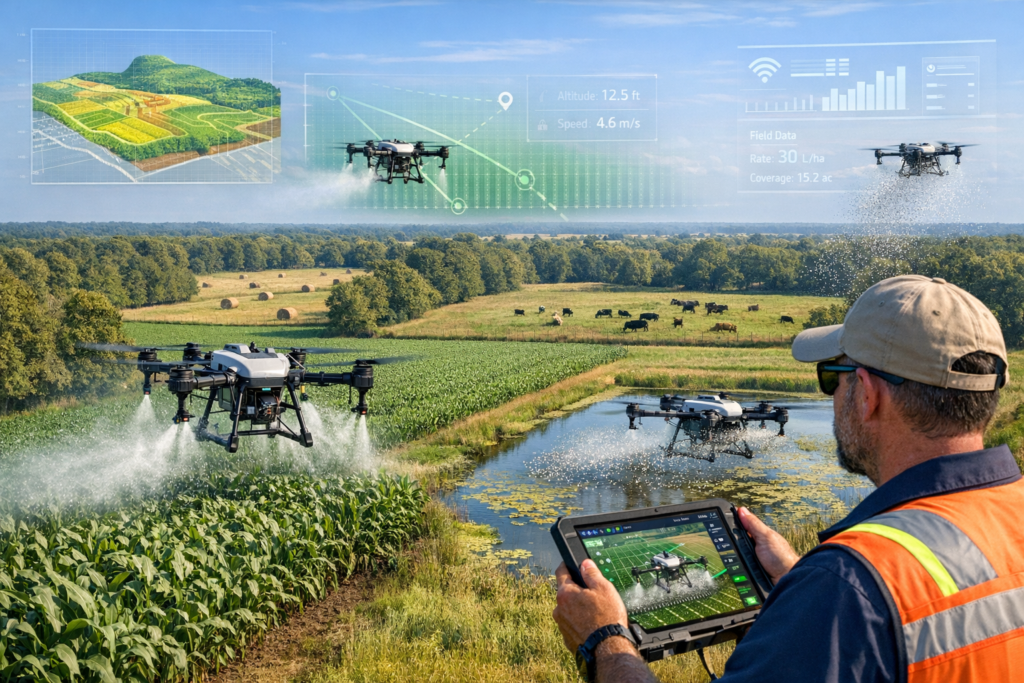
The arrival of commercial agricultural UAV technology changed the calculus entirely. Starting around 2015, manufacturers such as DJI began releasing purpose-built platforms like the DJI Agras series, culminating in today’s workhorses—the DJI Agras T20P and T40. These machines carry liquid payloads of up to 40 liters, fly GPS-guided flight paths at precise altitudes, and can be programmed to adjust flow rate and droplet size on the fly. For smaller and mid-size operations common among East Texas farmers and ranchers, drone spraying services suddenly offered something manned aircraft never could: affordability, accessibility, and field-level accuracy.
Why Agricultural Drone Services Outperform Traditional Methods
We frequently get asked what makes agricultural drone services meaningfully better than the old approach. The answer always comes back to three pillars: precision, safety, and economics.
– Precision agriculture technology allows our drones to follow variable rate application maps, delivering more product to stressed zones and less to healthy ones. That level of granularity simply is not possible with a fixed-wing airplane flying at 120 miles per hour.
– Drift reduction is dramatically improved because multirotor drones operate at altitudes of 6 to 15 feet above the canopy. The downwash from our rotors actually pushes spray coverage into the plant structure rather than letting it float away on the wind. Pesticide drift control is not just a regulatory concern—it is the difference between protecting your crop and accidentally harming a neighbor’s pasture.
– The cost per acre for drone spraying services on parcels under 500 acres is now competitive with, and often lower than, manned aircraft minimums, especially when you factor in mobilization fees and the ability to treat odd-shaped fields and pond margins that fixed-wing craft cannot safely access.
We have seen these advantages play out countless times while providing crop spraying in Longview and Palestine, where field sizes, tree lines, and power infrastructure make traditional aerial application challenging. Our FAA Part 107 certified drone pilots navigate those obstacles with ease, and the data we collect during every flight creates a feedback loop that makes the next application even more precise.
Core Agricultural Aerial Services That Drive Yield Improvement in Elkhart TX
Crop Protection Through Herbicide and Pesticide Application
Crop protection remains the single most requested service we provide. Whether we are tackling broadleaf weeds in a soybean field or managing armyworm outbreaks in coastal bermudagrass, aerial crop spraying with drones gives us the ability to respond within hours rather than days. Timing matters enormously in integrated pest management, and the speed of agricultural drone spraying means we can catch a pest outbreak before it reaches an economic threshold.
Our herbicide application programs are designed around the specific weed pressures common in East Texas. We deal with everything from ryegrass in winter pastures to Palmer amaranth in row crops. Each mission begins with a prescription map, often built from a previous imaging flight, that tells our system exactly where and how much product to apply. Variable rate application ensures we are not blanket-spraying clean areas, which saves chemical costs and reduces environmental impact.
Pesticide application follows a similar methodology. We calibrate flow rate and droplet size for the specific product being used, ensuring coverage uniformity across the entire target zone. A fine mist might be appropriate for a systemic insecticide that needs plant uptake, while a coarser droplet spectrum reduces drift when we are spraying near sensitive areas. This level of control is one of the reasons integrated pest management programs work so well alongside agricultural drone services—every input is measured, mapped, and recorded.
Fertilizer Spreading, Aerial Seeding, and Specialty Applications
Beyond crop protection, our agricultural aerial services include a growing list of specialty applications that East Texas farmers and ranchers are adopting:
– Fertilizer spreading and broadcasting with granular-capable drone systems allow us to top-dress pastures, food plots, and small-grain fields with urea, potash, or custom blends. We have applied fertilizer in wet conditions when ground rigs would create ruts and soil compaction, preserving the no-till profiles many of our clients have invested years building.
– Aerial seeding and drone seeding are gaining traction for cover crop establishment and overseeding winter ryegrass into bermudagrass pastures. Because our drones cause no soil disturbance, seed-to-soil contact can be maximized by timing the flight ahead of a rain event. This reduced soil disturbance approach aligns with conservation goals that many producers in Anderson and Henderson counties share.
– Pond and aquatic vegetation control is a service we are especially proud of. Many ranches around Elkhart TX have stock ponds choked with duckweed, water hyacinth, or filamentous algae. Treating these ponds from the bank is tedious and often provides inconsistent spray coverage. Our drones fly a programmed grid over the water surface, delivering herbicide with even coverage uniformity that ground methods cannot match. We have treated ponds and aquatic vegetation on dozens of properties, and the results speak for themselves.
– Pasture and hayfield management ties all of these services together. From spring weed control to fall fertilizer broadcasting to winter overseeding, aerial crop spraying drones give ranchers a year-round tool for improving forage quality. When we help a client increase hay yields by even half a ton per acre, the return on the cost per acre of drone application pays for itself multiple times over. That kind of yield improvement compounds year after year.
The Technology and Regulations Behind East Texas Agricultural Aerial Services
How GPS-Guided Flight Paths and Variable Rate Maps Work Together
One of the questions we hear most from potential clients is, “How accurate are these things, really?” The short answer: extremely. Our DJI Agras drones use RTK-corrected GPS-guided flight paths that hold positional accuracy within two centimeters. That means when we program a field boundary and a set of spray lines, the aircraft follows them with near-perfect fidelity, overlap included.
When we layer in a variable rate application map—generated from NDVI imagery, soil sampling data, or yield monitor information—each section of the field gets the exact dose it needs. The onboard computer adjusts pump speed and flight velocity in real time, maintaining the target flow rate and droplet size throughout the mission. Precision agriculture is not a buzzword in our operation; it is a measurable, auditable reality that shows up in the post-flight report we deliver to every client.
Agricultural UAV technology is advancing fast. The latest DJI Agras T40 platform, which we operate in our fleet, carries 40 kilograms of liquid and covers up to 50 acres per hour depending on application rate. Compared to the T20P we started with, the T40 nearly doubles productivity while offering improved spray coverage patterns and obstacle-avoidance sensors that make operations safer around tree lines and structures.
FAA Regulations, Licensing, and What Clients Should Look For
Operating drones for aerial application is not something anyone can legally do with an off-the-shelf quadcopter. All of our pilots hold FAA Part 107 certified drone pilot licenses, and our agricultural operations comply with additional exemptions and state regulations required by the Texas Department of Agriculture for commercial pesticide and herbicide application.
Here is what we recommend you verify before hiring any drone spraying services provider:
– Confirm the operator employs FAA Part 107 certified drone pilots. This is the federal baseline for commercial drone operations in the United States.
– Ask whether they hold a Texas Commercial Applicator License for the category of chemicals being applied. Aerial application of restricted-use pesticides demands this credential.
– Request proof of liability insurance specifically covering agricultural drone spraying. Not all drone insurance policies include crop treatment.
– Inquire about their drift reduction protocols. Professional operators should be able to explain how they manage pesticide drift control through nozzle selection, buffer zones, and weather monitoring.
We take these requirements seriously because agricultural aviation, whether manned or unmanned, carries real responsibility. Every flight we conduct for crop spraying in Longview and Palestine, and every mission over a hayfield or pond near Elkhart TX, follows documented standard operating procedures designed to protect people, property, and the environment.
Real Results: How East Texas Farmers and Ranchers Benefit From Precision Agriculture
Yield Optimization and Cost Savings We Have Documented
Numbers tell the story better than promises. Over the past two growing seasons, our agricultural aerial services clients in East Texas have reported measurable improvements:
– One cattle operation south of Elkhart TX reduced its annual herbicide spend by 28 percent after switching to variable rate drone spraying services. By treating only the areas of the pasture where broadleaf weeds exceeded threshold levels, we cut total product volume without sacrificing weed control. The cost per acre dropped from roughly $12.50 with a ground rig to $8.75 with our drone program.
– A hay producer near Palestine saw a 0.6-ton-per-acre yield improvement in bermudagrass after we implemented a combined program of spring herbicide application, midsummer pesticide application for armyworm, and fall fertilizer spreading—all delivered by drone. Pasture and hayfield management became a systemized, data-driven process rather than a reactive scramble.
– A recreational landowner with four stock ponds used our pond and aquatic vegetation control service and achieved over 90 percent duckweed suppression within three weeks of the first treatment. Follow-up imaging confirmed coverage uniformity that would have been impossible to achieve from the bank.
These outcomes reflect the core promise of precision agriculture: use data to apply the right product, in the right place, at the right rate, at the right time. Agricultural drone services make that promise accessible to operations of every size, not just the thousand-acre row-crop farms that can justify a quarter-million-dollar self-propelled sprayer.
Building a Data-Driven Farm With Aerial Crop Spraying and Imaging
Every flight we perform generates actionable data. Our as-applied maps show exactly where product was placed, at what rate, and under what environmental conditions. Over time, these records build a powerful dataset that supports smarter decisions about crop protection strategies, input purchasing, and land management.
East Texas agricultural aerial services are not just about putting chemical on a field. They are about creating a digital record of your land that grows more valuable with every season. When you combine aerial seeding records with germination imagery, herbicide application maps with weed-pressure surveys, and fertilizer spreading logs with yield data, you have a complete picture that enables true yield optimization.
We have clients who now use drone-collected data to negotiate better crop insurance rates, justify cost-share funding through NRCS programs, and make lease-renewal decisions based on documented productivity rather than guesswork. That is what it means to turn a field into a data powerhouse.
Our commitment to no-till and reduced soil disturbance practices also resonates with producers who are building soil health over the long term. Because our drones never touch the ground, we eliminate compaction, preserve earthworm habitat, and keep cover crop residue intact. These benefits compound silently but significantly, improving water infiltration, organic matter, and ultimately, yield improvement year over year.
Partnering With Doss Drone Services for Your Agricultural Aerial Needs
We built Doss Drone Services because we believe every farmer and rancher in Elkhart TX and across East Texas deserves access to the same agricultural aerial services that large-scale operations have enjoyed for years. Our team of FAA Part 107 certified drone pilots brings local knowledge, professional-grade DJI Agras drones, and a genuine passion for helping neighbors succeed.
Whether you need agricultural drone spraying for a 30-acre hayfield, aerial crop spraying across a 400-acre row-crop operation, drone seeding for a wildlife food plot, or pond and aquatic vegetation control on your ranch, we have the equipment, the licensing, and the field experience to deliver results.
Here is what working with us looks like:
– We start with a free consultation to understand your goals, field conditions, and budget.
– We build a custom plan that may include imaging flights, prescription maps, and a seasonal application schedule.
– We execute each mission with full documentation, delivering as-applied reports and recommendations for the next step.
– We follow up, because integrated pest management and pasture and hayfield management are ongoing relationships, not one-time transactions.
The future of farming in East Texas is data-driven, efficient, and precise. Agricultural drone services are not a gimmick or a luxury—they are the most practical tool available for crop protection, yield optimization, and sustainable land stewardship at a cost per acre that makes sense for real-world budgets.
If you are ready to see what agricultural aerial services can do for your operation, we would love to hear from you. Reach out to our team today at dossdronetx.com to schedule your free consultation. Let us help you turn your fields into the data powerhouses they were meant to be.