Construction teams in Elkhart, TX are moving faster than ever, but the jobsite still hides surprises: soft subgrade, shifting stockpiles, drainage issues, and plans that don’t match reality. That’s where aerial mapping services quietly change everything. When we capture high-resolution aerial imagery and turn it into measurable maps and 3D models, we help contractors see the whole site clearly, coordinate crews better, and reduce expensive rework. Instead of guessing quantities or walking acres with a clipboard, we deliver accurate, shareable data products that support daily decisions. Our goal at Doss Drone Services is simple: give you dependable drone data you can actually build from—without slowing down your schedule.
How aerial mapping services in Elkhart TX reduce rework and keep projects moving
When we talk with builders around Elkhart, the most common pain point isn’t a lack of effort—it’s a lack of visibility. A site can look “fine” from the ground while the grades are drifting, erosion is starting, or a subcontractor has staged material in the wrong area. With aerial mapping services, we create a current, measurable snapshot of the entire jobsite so you can spot problems early and correct them before they become change orders.
A big part of this is construction site mapping done on a consistent cadence. We often recommend construction progress monitoring weekly or biweekly on active earthwork jobs, then shifting to milestone-based flights once vertical construction begins. This rhythm keeps everyone aligned without creating extra meetings.
Construction progress monitoring that crews actually use
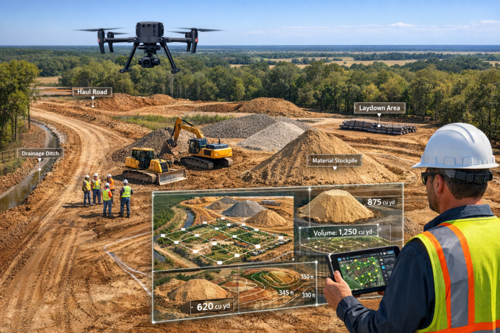
Progress photos are helpful, but progress maps change behavior. With aerial drone mapping, we produce orthomosaic maps (also called orthomosaic mapping outputs) that allow you to zoom, measure, and compare against prior dates. Those orthomosaic maps are more than pretty images—they’re decision tools. We can mark laydown areas, verify haul road paths, and document completed work for pay apps and owner updates.
Here’s how our clients typically use the deliverables:
– Compare weekly orthomosaic maps to confirm the site is tracking with the schedule
– Measure distances for fence lines, access routes, and staging plans
– Share annotated images with subcontractors to reduce miscommunication
– Document weather impacts and site conditions for records
Because the maps are consistent and measurable, they become a common reference point for supers, PMs, owners, and inspectors. That’s the quiet win: fewer arguments, fewer surprises.
Fewer change orders through better topographic mapping
Grade is where budgets get won or lost. We use UAV mapping methods to create topographic mapping deliverables like contour maps, digital elevation models (DEM), and digital surface models (DSM). When a contractor can see the actual surface as a measurable dataset, it’s easier to identify drainage risks and out-of-tolerance areas early.
We’ve seen topographic mapping prevent problems like:
– Ponding areas that weren’t obvious at ground level
– Overcut/undercut zones that would have required rework later
– Slope transitions that didn’t match the intent of the civil plans
In practical terms, better information leads to fewer “redo” days. And in construction, a single lost day can cost more than an entire round of drone surveying services.
From flight to deliverables: what we capture, how we process, and why it matters
Aerial data is only valuable if it’s reliable and repeatable. Our process for aerial mapping services is built around two priorities: mapping accuracy and consistency over time. It’s not enough to fly once and deliver a file; construction teams need a workflow they can trust month after month.
When we perform aerial drone mapping, we use flight planning and data processing steps designed to minimize gaps, maintain overlap, and improve the quality of the final outputs. We also plan around weather, sun angle, and site activity so we don’t interrupt operations.
Tools we use: DJI enterprise drones, RTK / PPK GPS, and GCPs
On commercial sites, we frequently deploy DJI enterprise drones because they’re dependable and built for repeatable missions. Depending on site conditions and the accuracy requirements, we pair our flights with RTK / PPK GPS workflows to improve positional precision. RTK / PPK GPS helps reduce drift and supports consistent results across multiple flight dates.
For projects that require tighter tolerances, we also set ground control points (GCPs). Ground control points (GCPs) serve as known reference markers that anchor the dataset to real-world coordinates. Used correctly, they help deliver mapping accuracy that supports serious planning and measurement.
We’re always transparent about what’s realistic. “Survey-grade accuracy” depends on the project needs, the methodology, and the site environment. When a client needs survey-grade accuracy for specific tasks, we discuss the correct approach upfront so expectations match the deliverables.
Photogrammetry and orthomosaic mapping: turning photos into measurable site intelligence
The core engine behind many deliverables is photogrammetry. We collect overlapping images, then use photogrammetry software to reconstruct the scene into measurable products. Good photogrammetry is part art and part science: capture settings, overlap, ground sampling distance, and processing parameters all matter.
From that photogrammetry workflow, we can deliver:
– Orthomosaic maps (a key output of orthomosaic mapping)
– 3D mapping products like 3D terrain models and textured 3D models
– Digital elevation model (DEM) datasets for bare-earth style analysis
– Digital surface model (DSM) datasets that include structures and vegetation
– Contour maps for grading and drainage discussions
This is also where consistency becomes powerful. When we repeat the same flight planning and data processing approach, your month-to-month comparisons stay meaningful. That’s how drone surveying services become a practical management tool instead of a one-off novelty.
For teams that want a deeper technical reference on photogrammetry and mapping fundamentals, we often point them to the USGS overview of photogrammetry concepts and applications: https://www.usgs.gov/
Construction earthwork, quantities, and planning: where aerial drone mapping pays for itself
Most construction leaders don’t need “more data.” They need fewer unknowns—especially during earthwork, when decisions are expensive and time-sensitive. This is where aerial drone mapping becomes a quiet advantage. It supports faster quantity checks, better scheduling, and clearer communication between contractors, engineers, and owners.
We see aerial mapping services deliver the biggest ROI when the site is changing quickly: mass grading, pad prep, detention excavation, or material import/export coordination.
Volumetric measurements, stockpile volumes, and haul planning
Stockpiles change daily, and manual estimates often turn into arguments. With UAV mapping and proper processing, we can produce volumetric measurements that are consistent and defensible. That includes stockpile volumes for base material, select fill, or excavated spoils.
Volumetric analysis is especially helpful when you need to:
– Verify supplier deliveries against expected quantities
– Track usage rate to forecast when you’ll need the next load
– Confirm export/import volumes during mass grading
– Reduce “we think it’s about…” conversations on the jobsite
We can run volumetric analysis repeatedly so your stockpile volume measurements aren’t a one-time estimate. For many teams, these stockpile volume measurements become part of weekly reporting.
3D mapping, DEM/DSM, and land development planning
Construction doesn’t start with concrete—it starts with decisions. When developers and civil teams are evaluating a site, 3D mapping supports clearer early planning. We regularly deliver 3D terrain models that help stakeholders understand slopes, drainage patterns, and buildable areas.
For land development planning, we often provide:
– Digital elevation models (DEM) for terrain-focused analysis
– Digital surface models (DSM) when surface features matter
– 3D mapping outputs that help visualize how a site “lays”
– Contour maps that quickly communicate grade transitions
Even when teams already have design surfaces, updated topographic mapping helps confirm what’s real right now. That matters when unexpected site conditions appear, or when schedules force phased grading.
And because land surveying with drones can be collected quickly without crews walking every acre, it’s often easier to keep plans aligned with reality. We’re careful with language here: land surveying with drones supports measurements and planning, but we also coordinate with licensed surveyors when a project requires stamped boundary or legal survey work. Done correctly, land surveying with drones complements traditional survey—especially for ongoing site updates.
Beyond construction: GIS mapping services and additional use cases we support across East Texas
Construction is a major driver for aerial mapping services, but the same workflow—high-resolution aerial imagery plus measurable datasets—supports other industries across the region. We’ve built our operations to handle repeatable mapping missions for different property types and decision-makers, not just one-time flights.
We also find that GIS mapping services become more valuable each year because owners want their assets organized spatially. When data is mapped and structured, it’s easier to track changes, plan maintenance, and communicate across teams.
Infrastructure, utilities, and property stakeholders
For utility and infrastructure inspection, aerial drone mapping helps teams assess corridors, access points, and surrounding conditions with less time in the field. While some inspections require specialized sensors, high-resolution aerial imagery can still provide meaningful context for planning and documentation.
We often support:
– Utility and infrastructure inspection planning with current aerial basemaps
– GIS mapping services for asset context and site overviews
– Real estate aerial mapping for large properties where a ground-only view misses key features
Real estate aerial mapping isn’t just for marketing. For commercial land and larger tracts, it supports due diligence and site understanding before purchase or development decisions.
Agriculture field mapping and forestry/vegetation insights
In our area, land doesn’t sit idle. Agriculture field mapping helps owners see boundaries, drainage patterns, and access routes more clearly. While advanced crop analytics may require multispectral sensors, standard aerial drone mapping with photogrammetry still provides strong value for planning, documentation, and property management.
We also support forestry and vegetation mapping when landowners need to understand overgrowth, clearing progress, or vegetation encroachment. Forestry and vegetation mapping paired with orthomosaic maps can make it much easier to communicate what needs to be cleared and where.
Across these industries, the deliverables remain consistent:
– Orthomosaic maps from orthomosaic mapping workflows
– 3D mapping outputs for visualization and planning
– DEM and DSM datasets depending on the goal
– GIS-ready layers when GIS mapping services are needed
And because we operate locally, our East Texas aerial mapping approach is designed for the terrain, tree cover, and weather patterns we actually deal with—not generic assumptions.
If you manage projects across multiple communities, we often support work in a regional footprint that includes Elkhart, Palestine, Longview, and nearby East Texas job sites. That local familiarity helps us plan missions efficiently and deliver consistent results.
What to expect when you hire Doss Drone Services aerial mapping for your next project
Hiring aerial mapping services should feel straightforward, not mysterious. We focus on a clean scope, a repeatable process, and deliverables your team will actually use. When a contractor calls us, we start by identifying what decisions you need to make, then match the mapping method to that goal—whether that’s orthomosaic mapping for progress, topographic mapping for grading, or volumetric measurements for materials.
Our workflow: scope, safety, capture, and delivery
Here’s how our projects usually run:
1. Define the objective (progress tracking, stockpile volumes, planning, or documentation)
2. Confirm accuracy needs (mapping accuracy targets, and whether survey-grade accuracy is required)
3. Plan the mission (flight planning and data processing approach, schedule, and site coordination)
4. Fly safely and legally with FAA Part 107 certified pilots
5. Process imagery with photogrammetry software and quality-check outputs
6. Deliver the maps and models in formats that match your team’s tools
We are FAA Part 107 certified pilots, and we take compliance seriously. That means we plan around airspace, site safety, and operational constraints. FAA Part 107 certified pilots aren’t a checkbox—they’re a commitment to doing commercial drone work the right way.
How we help you choose the right deliverables (and avoid paying for the wrong ones)
Not every project needs everything. Sometimes a clean orthomosaic map is enough. Other times, you need a digital elevation model (DEM) plus contour maps for grading conversations. And for earthwork-heavy sites, a combination of DSM data and volumetric analysis can give you the clarity you need.
We help you choose deliverables based on:
– Who will use the data (superintendent, PM, owner, engineer)
– What decisions are on the line (grade, drainage, quantities, scheduling)
– How often the site changes (one-time snapshot vs construction progress monitoring)
– Whether land development planning is still evolving
Our aim with Doss Drone Services aerial mapping is to make drone surveying services feel like a practical part of your project controls—not an add-on.
If you’re ready to see how aerial mapping services can support your next construction site mapping effort in Elkhart, TX, we’d like to help. Reach out through https://dossdronetx.com/ and tell us what you’re building, your timeline, and what you need to measure. We’ll recommend a flight plan, deliverables, and schedule that fits your job—so you can move faster with fewer surprises.